There's a site that tracks GPS jamming: https://gpsjam.org/
Makes me wish for the early days of the Internet where FAQ writing was good practice and writing a great FAQ was considered something worth celebrating.
* Does this map show spoofing? No.
* How come sometimes I see aircraft flying over Ukraine? That's GPS spoofing.
* [Add Myanmar & Kashmir to the list of conflict zones.]
https://spoofing.skai-data-services.com/
https://www.flightradar24.com/data/gps-jamming
Ukraine is of course a huge hotbed of jamming, but every time I've looked, there's been jamming on the US/Mexico border and a bit north of Texas around an airbase.
There's also a lot of info available here: https://www.nstb.tc.faa.gov/
Another problem is NOTAM spam; it seems like, in some areas, there are a bunch of NOTAMs that aren't very important but that you still have to read through to see if they're relevant. "We're testing GPS jamming" or "we will send a fighter jet if you fly into this rectangle" look a lot like the more common "taxiway T at Middle Of Nowhere Municipal Airport is out of service until 1/1/2038".
A1492/14 NOTAM Q) UKDV/QRTCA/IV/BO /W /260/320/4822N03807E095 A) UKDV B) 1407141800 C) 1408142359EST E) TEMPO RESTRICTED AREA INSTALLED WITHIN FIR DNIPROPETROVSK BOUNDED BY COORDINATES : 495355N 0380155E 485213N 0372209E 480122N 0370253E 471352N 0365856E 465018N 0374325E 465900N 0382000E 470642N 0381324E THEN ALONG STATE BOUNDARY UNTIL POINT 495355N 0380155E. RESTRICTION NOT APPLIED FOR FLIGHTS OF STATE ACFT OF UKRAINE. F) FL260 G) FL320)
Besides that, would the developer of the LLM accept liability for accidentally filtering out important NOTAMS, or hallucinating NOTAMS that did not exist?
And for some further context: the quote upthread of "NOTAMS are a bunch of garbage that no one pays any attention to" from NTSB chairman Robert Sumwalt came after Air Canada flight 759, which would have had >1000 fatalities if two airplanes were a few feet closer: https://en.wikipedia.org/wiki/Air_Canada_Flight_759
This NOTAM (Notice to Airmen) establishes a temporary restricted area within the Dnipropetrovsk FIR (Flight Information Region) in Ukraine. The restricted airspace is defined by specific geographic coordinates, forming a boundary for the restricted area.
Key details include:
- *Effective Dates:* From July 14, 2014, at 18:00 until August 14, 2014, at 23:59, with the "EST" indicating that the end date might be subject to change.
- *Altitude Limits:* The restricted area applies to flights between FL260 (Flight Level 260, approximately 26,000 feet) and FL320 (approximately 32,000 feet).
- *Exemptions:* The restriction does not apply to flights of state aircraft of Ukraine, meaning those aircraft can operate within the restricted area during the specified timeframe.
Pilots and airline operators should be aware that flights not exempted by this NOTAM must avoid this area or adjust flight levels accordingly to comply with the restrictions. For further guidance, they should consult official aviation authorities or current NOTAM listings, considering the potential for changes.
I don't buy it. How often do you hear of a passenger plane getting shot down for entering restricted airspace over peaceful territory like the US? What about over combat zones, like over Ukraine or Russia? Who in their right mind equates these as as equally severe? If you had to make an emergency landing would you seriously view these equally?
> At least within the US, entering a restricted area without authorization can result in your own personal military air show, followed by lots of questioning, possibly prison, losing your license or both. You don't mess around with restricted areas unless you have a damn good reason.
You're not taking my point.
I don't know about you, but I would sure as hell prefer prison over myself and hundreds of other people falling from 40,000 feet.
On the one hand, that would be ideal.
On the other hand, that appears to be a NOTAM restricting access to an active war zone. It is truly tragic, and should be avoided whenever reasonably possible, but sometimes civilians who enter war zones get killed.
So, (just so you know) the "they flew into an active war zone" bit is probably the reason why your point is being brushed aside. Restricted airspace is restricted airspace. Unless you're on the unrestricted craft list, you simply don't enter it.
Compare it to the DC SFRA[0] which specifically states "MAY USE DEADLY FORCE" even though that's extremely unlikely to happen.
When Flight Restrictions are active in FAA controlled airspace, ATC will often clear you through them if you're on an appropriate flight plan without you needing to ask. Even the 'deadly force' SFRA above is essentially handled for you so long as you file an IFR flight plan.
[0]: https://www.faa.gov/air_traffic/publications/us_restrictions...
If it makes you feel better, here's the current TFR over eastern Ukraine. It even explicitly says "danger" - does that make you feel better?
TEMPO DANGER AREA ACT WI COORD: 434800N0392400E-433000N0303500E-441500N0302500E-...
https://www.ainonline.com/aviation-news/business-aviation/20...
If I'm flying cross country, in to controlled airspace, or an airport I'm not familiar with, I will. But this particular notam didn't show up when I looked at nearby airports.
Even worse than jamming is spoofing, which Russia also does. With jamming, you and the aircraft's systems both know what's happening. Spoofing isn't as easy to detect, as the GPS system can report the wrong location but think it's highly accurate. Spoofing (and to some extent jamming) can have a persistent effect on aircraft systems even after they move out of range of the jammer/spoofer, which can lead to degraded navigation accuracy for the rest of the flight.
It's a whole deal. Russia is messing with strategically important systems of many European countries, and decreasing civilian aviation safety, and they rarely get called on it. For a long time there was reluctance to even name Russia as the culprit.
1. https://www.heise.de/en/news/GPS-jamming-no-more-flights-to-...
I feel like we had airports before we had GPS. If this is a regular thing, shouldn't we have ways of using the airport without hoping that the jamming is having an off day?
How about we treat enemies as actual enemies, rather than rolling over and letting them make our lives more difficult?
In comparison to the US's power, Russia is an annoying pipsqueak, but instead we are letting Russia boss around on everything. It's shameful and embarrassing.
Why in the world should we have to rely on inferior methods?
Treating someone as an actual enemy means accepting that sometimes they're going to do things that are inconvenient for you.
> Why in the world should we have to rely on inferior methods?
Well...
treating someone as an actual enemy means accepting that sometimes they're going to do things that are inconvenient for you.
Ignoring what a bully does has predictable consequences.
And other, far more wise people, might realize that appeasement of bullies throughout history has resulted in some of our very worst wars and the most horrific atrocities that humanity has ever committed. Weakness invites conflict and destruction from the bullies of the world, and when it comes to war, the bullies gain materials and conscripts when they are allowed to conquer.
(I think we are very much on the same page, thank you for the comment.)
They are nobles arguing about who has to take time away from the dinner party to shoo away a miscreant throwing tomatoes. Except for the Baltic States, who take it more seriously at the moment, but that will change as soon as the Vatniks on the political extremes are finally removed.
Additionally, good luck finding young men who want to fight for their country in the west of Europe. New arrivals will not lay down their lives as they often hate their host countries and people. Heritage Europeans are massively discriminated against by their own governments for speech crimes, on top of race and sex-based discrimination. A very small amount of men will fight to continue that state of affairs.
Second, Ukraine is invading Russian territory, occupies it, and no nukes yet! The supposed nuclear threat is empty and stupid.
Third, if you think for a fucking microsecond that 90% of Polish men are not ready to go to war and kill Russians you have never talked to a Polish person. They know what is at stake.
Fourth, even the UK is talking about boots on the ground and planes in the air over Ukraine, https://breakingdefense.com/2025/03/amid-us-rift-with-ukrain...
Fifth, fighting these completely made up narratives that have no basis in reality is exhausting. It's almost as if an entire population has decided that they misread the commandment to be "Though SHALL bear false witness."
UK is talking about boots on the ground. Wake me up when they actually have a sustained, large-scale presence.
Europe has paid Russia more (for their natural gas) than they have given aid to Ukraine during the duration of this war. Europe is totally cooked.
This post has several comments along the lines of "We used to fly without GPS and it was fine!" The fact is that aviation is so much safer than it used to be, and GPS is part of that. GPS helps aircraft navigate accurately even when they're not near an airport. It helps give situational awareness and avoid mid-air collisions (almost every aircraft these days has a traffic display that shows ADS-B positions of other nearby aircraft, and those positions come from accurate GPS).
Loss or spoofing of GPS isn't usually a critical safety issue on an aircraft, but it definitely removes layers of safety and adds additional risk. Pilots can lose that situational awareness of nearby traffic. They may have increased workload and distraction due to having to use a less familiar & less accurate means of navigation, trying to figure out why their systems aren't working correctly, and even getting bogus ground proximity warning system alerts. ATC may now have increased workload and distraction because some approaches or even runways are no longer usable.
We drove cars for a long time without seat belts and air bags, too.
And if we were having problems with seatbelt jammers, everyone would instantly respond by just not using seatbelts in those areas. There would be no road closures and no trip cancellations. What are we supposed to learn from this analogy?
The more apt analogy is what would our roads look like if all traffic signals stopped working? People would still drive, but it would have to be at lower speeds, with more congestion, etc.
This happens pretty frequently with single signals, so we know what that looks like.
An unattended broken signal gets treated like a stop sign (by law), and this immediately blocks traffic. It's a total disaster.
If it happens anywhere near a population center, a human will be dispatched to cover for the broken signal and dysfunctional law by manually directing traffic, and this gets you almost all the way back to normal.
If every signal failed at once, that would cause much bigger problems, but in the event that we know we're unable to repair the signals, which is the case here, we wouldn't just try to muddle through using the existing roads and systems. We'd define new systems that worked better in the absence of traffic lights.
"If this is a regular thing, shouldn't we have ways of using the airport without hoping that the jamming is having an off day?" Yes. But it takes time and money. This level of GPS interference is relatively new, and for about the past 30 years you could basically assume GPS would be available.
However, they were not in use a few years ago. Some airports never had the ground based equipment installed, others still had the beacons functional but the procedures (STAR, SID) had been phased out in favor of the easier and cheaper satellite based GNSS RNAV procedures.
Some airports had brand new VHF equipment installed, others had the old procedures reinstated.
But aviation is a slow moving, risk averse, cost sensitive business so several airports were inaccessible (apart from visual approach) for a few months.
one of the things that made GPS available for civilian use was the Korean Air Lines Flight 007 incident.
Anyway, awesome site regardless, and OSM tiles are fine if not abusing their hosting (this isn't I'm sure).
* https://rntfnd.org/2025/02/26/faa-moving-toward-crpa-on-airc...
One tripping point is that in the US, CRPAs are on ITAR, so exports are difficult:
* https://www.gpsworld.com/first-fix-freeing-crpas/
Given that GPS/GNSS comes from satellites, ignoring signals from not-from-the-sky seems like a quick win.
You're right, but GPS antennas already have some rejection from the "bottom" hemisphere. So they're already rejecting not-sky.
CRPAs (of the type contemplated by ITAR) are electronically steerable antennas (phased arrays), that allow you to steer one or more nulls to the direction of the noise source(s). That gives much better rejection of point-source noise.
https://insidegnss.com/crpas-to-be-removed-from-itar-list-op...
These systems have been used used in military aircraft for a long time.
*Trilateration
One measures the time of flight of the satellites signal, not the angle it arrives from!
… if you can get the precision to filter that out…
Using an accurate clock, you might be able to detect spoofing (by detecting small “jumps in time”). However, the same should be possible even with a non accurate clock (a few ppms) by detecting conflicts between the different satellites timings (since the “fake” transmitter is on earth, it will never be able to accurately simulate the real satellites’ airtime delays from space to your specific reception location).
On the other hand, if you pair a very accurate clock with a very accurate gyroscope, you might be able to replace gps altogether (https://en.m.wikipedia.org/wiki/Inertial_navigation_system) But from my knowledge, these kind of gyros are not really available for sale (but this is already outside of my knowledge, so maybe something changed).
Dead reckoning systems are available with varying degrees of accuracy and drift depending on your budget. It's common to use them to guess location during GPS dropouts, such as driving through tunnels.
More accurate systems are available as budget allows and the military has a lot of research on this topic. Error accumulates over time, so the longer you go without a GPS reset, the worse the precision gets.
You can't fully eliminate the error accumulation over time, so they can't completely replace GPS. You still need some way to periodically refresh your ground truth position.
The clock is not the hard part of this. Oscillators doing 10mhz or 1pps with nanosecond accurate holdover for 24hours are easily available (for like 3k for chip-scale atomic clocks, and less for rubidium or whatever ).
Galileo et al also have publicly available cryptographic signatures so you can't actually spoof them, only jam them.
If you are trying to do navigation while jammed, the reckoning is the hard part of this, not the clock.
We solved the clock enough already.
Replay attacks still work allowing one to spoof location.
The replay attacks i'm aware of fall into two categories - cold start and warm start (mostly from https://arxiv.org/html/2501.09246v1, which has been in progress for a while)
The cold start replay attacks are irrelevant here - unless you can force-restart the gps receiver in cold start mode during flight. If you can do that, you probably don't need to spoof the signal. Especially since it requires precise timing to forge the new signal to the receiver at the right time (otherwise it detects it), etc. Seems like there are easier ways.
The warm start replay attack A. Requires you replay valid, but out of date, signals, in real time. This is non-trivial, and also limited in effect as you can only arbitrarily spoof one receiver to a location of your choosing - maybe you can get a few receivers with really good high-signal strength directional beaming of different replays, but it requires real-time tracking and adjustment of the signal of the target anyway to be able to spoof the location accurately.
Spoofing the location inaccurately is sort of pointless in most cases.
B. The attack has to change the time (and thus location) slow enough to not trigger various protections, then keep changing it slowly enough to continue that.
C. The attack requires that your receiver is too stupid to notice that a forced revert to non-authenticated time occurred, doesn't notify you of this, and then doesn't notice that time or location jumped suddenly by more than any reasonable amount. It also has to not notice that the SNR of everything suddenly changed, etc. Oh, also, they have to spoof all other sources of time, including local oscillators, etc, for you to not notice.
Given we just talked about how cheap and easy it is to have a high quality oscillator disciplined to time before takeoff, this kind of replay attack seems "practical" only in the sense that it is possible.
Are you aware of other replay attacks, if so, that'd be cool :)
Otherwise, yes, I agree you can spoof location in theory. I can't imagine a practical application of it in the scenario we are talking about.
disclosure - I do work on a team developing MagNav, but much of the seminal research has come out of the Air Force Institution of Technology. They performed it on an F16, paper results shown here https://ieeexplore.ieee.org/document/9506809
https://www.sagemotion.com/blog/how-does-imu-sensor-fusion-w...
But for most cases, MagNav should do the job. Happy to answer more
1. Roughly how long does it take for MagNav to get a "lock". For example, GPS takes 10 or 15 seconds (at least consumer stuff I have access to). Also, with GPS the accuracy improves if you're moving. I assume it may be similar with MagNav but it would be an interesting advantage if MagNav got a lock super fast vs GPS and/or it was basically at 100% resolution without needing to move (and I understand MagNav's "100%" res is much lower than GPS).
2. What's your drive-by guesstimate on probable future evolution of MagNav tech on the 'Four Horsemen' of mobile tech (size, weight, power, cost)? For example, which of the four are more like "No reason it can't improve a lot if given sufficient time, funding and development with no new science required" and are more "Well, physics/materials are currently an unsolved, seemingly fundamental barrier to improving beyond X threshold." In a perfect world... (the one we don't live in), MagNav would be on a five year productization track that'll put it inside an Micro SD card footprint with negligible power budget at 25 cents/ea by the million and be common in small Costco drones as a fallback if GPS fails.
Also, nicely appropriate username :-)
2. Since I work for a company in this area, I can't say too much, but SWaP is definitely going to decrease. Right now I think you could decrease size to a midsize cereal box. I don't think a super accurate version would exist for phones yet. Power consumption is somewhat low, but you need a serviceable GPU and RAM, like an Apple M3 to run things. Power consumption will improve with improvements in compute.
I think cost is the most prohibitive of them all, because quality magnetometers and INS are not cheap. > $20K per unit at least. i'm not talking MEMS grade stuff you see in phones and student projects, I'm referring to Tactical/Navigation grade—the stuff you see on military platforms. I think you'll see MagNav on military planes much faster, due to their mission-critical needs. For commericial planes to use them at scale, one needs FAA clearance which is a bottleneck for good and bad reasons.
We're not in a perfect world yet. MagNav will take some time to develop. What I think is missing is a larger community to work on this issue. There isn't that much motion in the space. Less than 5 serious players in the game, IMO. There also aren't that many suppliers who make the parts (magnetometers, etc.) you need for MagNav.
Lots of more thoughts here, but if anyone wants to chat more, contact me at sir.claude.shannon@gmail.com
I imagine larger military drones which need to navigate autonomously for extended periods over denied environments in all conditions are very interested in MagNav as a component in their sensor fusion suites. Even narrowing the current position to less than a square kilometer would make the identification problems faced by other sensors like optical much easier to solve.
I've never heard of that - what is it? What's it like to work with them (if you did)?
GPS is incredibly flimsy. Normally it operates by taking the average of 1000 observations to generate a noisy signal. It's not that difficult to be louder than something shouting from space. You can pick up cheap GPS blockers easily about the size of a walkie-talkie (handheld radio).
> By carrying a group of atoms cooled to -273C on the plane itself, rather than relying on an external signal, the technology can't be interfered with by jamming.
Last year I was on a plane where if the engines were not running, it entirely went into darkness. They hooked the plane up to the airport and tripped the airport electrics too. Now imagine if your plane loses power momentarily, and suddenly your GPS stops working entirely.
> Henry White, part of the team from BAE Systems that worked on the test flight, told BBC News that he thought the first application could be aboard ships, "where there's a bit more space".
> Quantum clocks, gyroscopes and accelerometers are large, bulky and incredibly expensive, with an accurate quantum clock costing around £100,000. Yet military research is allowing the creation of smaller, better and cheaper systems.
Likely a minimum of 10 years from being viable. Mt White of BAE is politely saying as much.
https://en.wikipedia.org/wiki/Chip-scale_atomic_clock
Apparently they're not even export-protected, despite their obvious use in GPS validation schemes and in RTK.
> The SA.45s CSAC has an Export Commodity Control Number (ECCN) of EAR99. This means it is not ITAR-controlled and does not require a special license to ship to most nations. The SA.45s CSAC classification is controlled by the Bureau of Industrial Security (BIS) within the US Department of Commerce.
The article talks about quantum "optical clocks" but doesn't really explain the concept.
Which appears to be this:
https://en.wikipedia.org/wiki/Quantum_logic_clock
Which, like many things named "Quantum", still doesn't really explain how you get an IMU out of it.
It’s true that optical clocks will improve the accuracy of our measurement of time, and it’s true that GPS depends on time, but there are several steps between primary frequency standards (ie, optical clocks) and GPS, and several more steps between GPS and navigation applications.
So optical clocks cannot, in fact, have any effect on the end-user perceived reliability of GPS.
For that, the best solution is to revive LORAN which is much less susceptible to jamming. (And would also benefit from better atomic clocks.)
Finland is reintroducing DME: https://www.reuters.com/business/aerospace-defense/three-fin...
Which seems to be a different concept from LORAN, but still useful for navigation when multiple base stations are in range.
https://www.theguardian.com/science/article/2024/jun/15/lond...
Indeed it’s being examined precisely for this application:
https://newatlas.com/aircraft/quantum-navigation-infleqtion-...
Now imagine your plane loses power momentarily and switches to a backup system... The exact same GPS every plane is using today.
It is usual to be able to abort an approach and try again at the same airport using a different approach technology. But if the journalist wanted to find the most extreme example, it's not surprising that it happened at least once that an alternative wasn't available. This is probably "sampling bias"!
Note that final operational decisions are made by the aircraft commander. Aircraft do not "get diverted", except by decision of the "captain".
Source: my guess after watching a lot of aviation YouTube videos......
It's best practice/policy for all major airlines to use stabilized approaches and most/all require a go-around if the stabilized approach is interrupted (there are edge cases and exceptions).
To be honest, I don't think most people realize GPS is coming from satellites in the first place. Most people simply don't think about how/why at all when using things.
https://www.u-blox.com/en/blogs/tech/gnss-spoofing-new-secur...
... and this term only appears in the headline, not (anywhere!) in the body text. Wonder if the author of the article intended that term to be used, or whether the (sub)editors put it in to help get more clicks?
Typical indications of Spoofing
Unlike jamming, a GPS signal is present, but it has fake information. False GPS position, time, and date information will be processed by the GPS receiver as being valid. As soon as this is fed to other systems, failure messages will begin.
• Rapid EPU or ANP increase
• GPS position and IRS or FMS position disagree caution message
• Aircraft Clock time changes, or difference between Capt/FO clocks
• Transponder failure: EICAS/ECAM “ATC FAIL”
• Autopilot turns aircraft unexpectedly
• ADS-B Failure/Warning
• Synthetic Vision reverting to blue over brown
• Loss of enhanced display, such as display of terrain on PDI
• Wind indication on ND is illogical or has a major shift - erratic groundspeed
• GPS position symbol on ND drifts away from the FMS and the IRS symbols
• Datalink (CPDLC, ADS-C) failure warning
• GPS information on sensor page shows unusual values: altitude, etc.
• Handheld GPS (e.g. Garmin, iPad) disagrees with aircraft GPS position
• EGPWS audible warning (‘Pull Up”)
• GPS 1 and 2 dramatically different i.e. more than 100 meters, which may also give an ECAM/EICAS GPS miscompare warning.
• Spoofing Alerting app e.g. Naviguard gives alert
• ACARS message from ground/ops advises of spoofing (based on aircraft downlink message with unusual values)
[1] https://ops.group/blog/crew-guidance-published-by-gps-spoofi...
That does raise an interesting question though - do missles actually depend on the standard atomic clock signals? Maybe that isn't how they did it, that seems like a dependency you wouldn't want in a weapon.
But would Iranian missiles even use GPS? Isn't accuracy limited for civilian use for precisely this reason?
Regardless, if you’re building a long range missile, you need some ability for it to navigate. If you’re not using GPS, then what would you use instead? Additionally there’s nothing preventing you from using multiple navigation systems in tandem and fusing the results together, which is almost certainly what these missile do.
Sensor fusion reduces the impact of stuff like GPS jamming, but certainly doesn’t eliminate it. The over all system will be less accurate with fewer inputs, and if you’re the one faced with a high speed missile flying at you, I suspect you’ll take every edge you can get, regardless of how small the impact might be.
[1] https://en.m.wikipedia.org/wiki/Error_analysis_for_the_Globa...
US ICBMs and submarine-launched ballistic missiles use a combination of inertial and celestial navigation: in space of course there are no clouds to obscure the stars:
https://en.wikipedia.org/wiki/Celestial_navigation#:~:text=I...
Not to mention, if you're designing a cruise missile, you're not that bother about how your navigation system might interfere with other aircraft, or ground systems in the area. I doubt having thousands of planes flying around shooting radar straight down at the ground would work particularly well.
We did this to trial some new (at the time) surveying equipment when the primary equipment was optical. It would save time for really long measurements through the forest and mountainous terrain .
Getting correction data from a node a few dozen kilometers away isn't quite as good as having your own fixed base station a stone's throw away, but it's way more convenient and for a lot of applications plenty accurate.
There are rules about GPS hardware that say that they should cease working above certain speeds and altitudes for guided missile purposes. But that is a firmware issue. I’m sure the Iranians have figured that out if the are even using off the shelf hardware.
Depending on the receivers and what (combination?) of GPS/GLONASS/GALILEO/BAIDU Iran uses, you could easily overwhelm them.
There have been cases of delivery drivers using jammers to stop companies from tracking them, only to interfere with airport landing systems, which is a concern as a lot of warehouses are near airports.
EDIT: power at ground level is miniscule
Did you lose 16 orders of magnitude for the sea level values? GPS signal strength on the ground is usually below -135dBm per square meter. That gives you a couple of femtowatts with commonly used antenna, if you're lucky.
Easy to jam doesn't begin to describe it.
GPS signals are weak since they come from far away
Are they somehow able to determine position via dead reckoning? How does that account for errors from wind, vibration, etc. and compounding of errors over time? (I'm pretty sure dead reckoning is not a closed-loop system)
"Miniaturize a very accurate clock" seems like a fairly straightforward engineering challenge. "I can give you clocks as precise as you need, now design me a system that can give your coordinates in thick fog without GPS or any other external radio signals" seems like a much harder one.
I doubt they're navigating using the sun an stars, but if the airspeed indicator is accurate, and you know you're heading, all you need is an accurate clock to determine absolute position since the last known good position.
Airspeed gives speed relative to the air, not the ground. To compute ground speed, you also need winds aloft, which can be huge if the aircraft is operating in the jet stream.
Getting good data for winds aloft is difficult because there are a relatively small number of actual measurements, and everything else is model output with all the usual caveats.
Am I missing something?
Now suppose someone is spoofing your GNSS signals, it's pretty hard to replace a constellation with another one whilst maintaining time consistency for you. One way to detect spoofing is comparing what a local clock is saying to whatever the GNSS is giving. A local, unfudgeable, stable, accurate clock is a good reference for this.
Assume you want it even super accurate.
Great, 3k for an SA65 https://www.microchip.com/en-us/products/clock-and-timing/co...
Holdover would be fine for even a very long flight.
Hell, even a good rubidium oscillator doing 1PPS will stay within 200 nanoseconds over 12 hours.
If you are trying to do navigation while jammed, none of these help you.
You still need good reckoning, which is the hard part
We done solved the clock problem enough already :)
I'm happy to learn this is not the case for every good oscillator. TIL.
But when they speaking about near zero temperatures, looks like they talking about something like Rydberg atoms - extremely sensitive matter, which could be considered as nuclear scale gyroscopes, or quantum gyroscopes, or read more about quantum accelerometer.
And current inertial navigation could be used to calculate relative coordinates like automobile odometer, but from integrating accelerations. But classic accelerometer is just not fine enough, and at this place appear quantum accelerometer and quantum gyroscope.
And I agree, article is terrible. I don't know why they use so abstract language, when could just say, navy already tested quantum navigation.
Planes flights are much more lengthy than rockets - I think, typical ~40 minutes or more (most long I hear 20 hours), so INS could integrate huge mistake.
And civilian education now close to forgot star navigation, but navy still train people to navigate with stars and learn Morse code.
Detect semi-surfaced submarine at night is really hard, if don't have intelligence data that it will surface on some non-random position.
From experience of Ukrainian war, my country have success with eliminating surface military ships, because have constantly monitoring their moves with satellites, but I cannot remember any case when semi-surfaced submarine was hit.
At a guess, Ukraine probably can't deploy naval assets with powerful radar close enough to where Russian subs are operating. But an adversary with a more powerful navy might be able to.
In these words you hit bull eye.
During WWII, submarines was just very special type of boat. You could check wikipedia about German u-boats - exist about TEN subtypes, from which only latest types have really significant underwater range, but all others was extremely limited in underwater activity.
But, surface ships of that time was even more limited, many could not achieve even half of surface speed of u-boat, so become easy prey.
But if you will try to find some artificial object on sea surface, that is really hard question. Just because sea is huge, so you need to check extremely large space in short time.
Radars are better to spot artificial object on sea surface than visual, just because radar easier to automate. But nothing more. Radar is also have problem of square distance, very similar to visual. So, as it is hard to spot partially surfaced submarine visually, it also hard to spot such sub with radar, because much less part will be on surface, so radar will have much less signal to detect.
Periscope size is nearly undetectable on surface, if it used carefully, just outside detection range of radar.
So, to conclude, Ukraine problem is, we cannot detect partially surfaced submarines on open sea, but they could fire missiles. Fortunately, Russians have very few submarines on Black sea, and after they was hit at harbors, their usage become very limited.
Agree with most of what you said, but U-boats generally had top surface speeds under 20 knots and were thus slower on the surface than most naval vessels of the time. They could certainly move faster than most convoys, but they couldn’t outrun pursuing destroyers or corvettes.
That is point. I'm not agree about most, but will be agree if you say about many.
> they couldn’t outrun pursuing destroyers or corvettes
But problem was, navy have so huge deficit of ships, so some convoys was run without naval support.
Sure, if all convoys was supported with fastest ships with best commands, u-boats will be no problem anymore, and as I understand, once this was happen.
Ballistic missile submarines are a completely different story. They aren't chasing anyone. Their entire goal is to be unpredictable and stay hidden, so if there's anyone with a radar around they are just going to keep quiet and move somewhere else.
Finding a sub prowling a shipping route is quite doable. Finding a sub in the middle of the Pacific Ocean? Not a chance.
When Ukraine got enough weapons to force Russian ships to stay at distance, situation changed dramatically, so export was unblocked.
I think, very similar things happen during WWII.
This is not about only submarines, this is about superiority.
They are, if you can get your radar on top of the periscope, e.g. mounted on a plane that flies above the sea.
https://en.wikipedia.org/wiki/LORAN
Before LORAN, used radio beacon navigation and star navigation (from Newton time), and good human navigator could achieve about 50km precision.
You could easy see signs of star navigation on good preserved old planes - they all have some sort of fully glass dome, or blister, to provide good near semi-sphere view. And sure, all those before-GPS era planes have separate navigator job position, sometimes shared with mechanic.
https://www.reddit.com/r/WWIIplanes/comments/59xfkz/pby_wais...
You could ask, how planes could fly with 50km precision? Answer is easy - at all plane routes built ground structures easy seen from air and last mile navigation become essentially visual flight, nothing more, nothing less.
On some places ground navigation structures preserved now, for examples:
https://en.wikipedia.org/wiki/Airway_beacon
https://en.wikipedia.org/wiki/Transcontinental_Airway_System
Perhaps in general aviation, but I can't think of any modern commercial airliner without an INS via the air data inertial reference unit.
The INS unit is separate and often has its own set of gyros and has to be connected as separate input to FMS or other navigational computers, same as connecting GPSes or other radio nav components.
For example the current model of popular Universal Avionics UNS1 series of NCU (navigational computer part of FMS) come with built-in augmented GPS receiversz but do not mention INS functionality at all even in extended models. Don't have access to manuals at the moment, but I'd expect to see INS as optional to connect over one of the external connectors on the MCU, as it was on the older models without integrated GPS
I had assumed that the ADIRU’s inertial reference data from its gyroscopes and accelerometers would feed into the FMS to provide INS capabilities in case GNSS was unavailable.
GNSS becoming "reasonably easy" to add meant that there was way less push to integrate INS after early use in transoceanic flights
Daily rotation is 360°/23.934h, so 0,25°/min, which is acutally quite a lot if you want to use a device to track your orientation.
Better are quantum navigation systems, using quantum matter as sensor, but they was too bulky to be used on planes, only last years appear more compact systems, sized like common home fridge.
Minor FYI: the earth rotates daily, but it revolves around the sun yearly.
    revolve /rĭ-vŏlv′/
    intransitive verb
    To orbit a central point.
"The planets revolve around the sun."This is the principle gyrocompasses work on; when left running for a while they align themselves with true north; the axis of Earths rotation.
something like Decca or LORAN are really simple to understand: two or more base stations in a known location emitting phase locked signals. By counting the nodes/antinodes of the harmonics, you can work out how far away you are from the base stations. The downside is that you need a initial fix to work out absolute location.
The thing thats kinda touched on here is that GPS uses clocks to allow the receiver to work out how long the signal has been in flight (simplification) If you know where the satellites are (using the Almanac of satellite positions) you can get your location by fairly simple triangulation.
Now, you don't have an atomic clock on your receiver, so how can you accurately measure the time difference between signals?
for GPS you only need to know the relative time difference between each satellite, and even thought quartz clocks are only accurate to seconds a year, in the ~20-50ms it takes for the signal to arrive, its more than accurate enough.
However that means you are open to spoofing, because you sync your local clock to a satellite, you have no real way of detecting if the clock has skipped.
If you have an accurate clock source, you can then validate the clocks that are on the transmitters. I think, but can't confidently assert that calculating position becomes easier because you have an authoritative clock source, so don't need to piss about with clock sync using an unknown time offset.
I think the implication is that this provides a strong form of signal authentication.
However chipscale super-stable clock references also allow more autonomous styles of navigation. (ie celestial)
Simply because it’s possible to fly without GPS doesn’t mean it’s commercially viable. Remember, before GPS, direct transatlantic flight weren’t generally possible because there’s no radar or radio coverage out there to help with flight navigation. Also for a long time, plane navigated by flying low and literally following giant arrows on the ground[1]. I doubt anyone is particularly keen to return to that kind of navigation.
> before GPS, direct transatlantic flight weren’t generally possible
I'm not sure what you mean by this. Commercial transatlantic flight picked up after WW2 in the 50s. By the 1970s it was fairly common. A lot of that came from rocketry research and INS.
https://www.smithsonianmag.com/air-space-magazine/707-flight...
GPS (and other GNSS) make civil aviation slightly safer and more efficient but it's hardly necessary for routine flight operations.
Except guess what! Many of the VOR stations in the USA have been shut down, due to the high availability of GPS!
You just have to get closer to the source and find better information: https://www.gpsworld.com/uk-government-tests-quantum-inertia...
Which seems to be hard seeing as how the Russian government is good at convincing people (mainly their own, Europe's elite, and members of the Republican Party in the US) that it's okay to do what they do.
https://www.theguardian.com/us-news/2025/feb/28/trump-russia...
Which implies that we don't need to worry about Russia jamming GPS on our planes, they are just trying to help. Just flow with it and stop panicking.
In the air, there are always more GPS satellites visible than necessary. So jam-proofing through signal processing methods is the way to go.
Most of the chips and as such the receivers are supoorting all of these systems in parallel. While I understand that the Chinese use their own coordinate system, I don't if BAIDU is based on that or not. Galileo is available. Galileo is able to use authenticated signals. Galileo has much improved over GPS. I assume in (important) comercial applications like aircrafts, you could use the better Galileo service for which you have to pay for.
So how important is GPS spaming really?
Which has optional cryptographic signatures of its positioning data. It's not spoofable anymore (but still jam'able with strong transmitters).
Free for use.
(https://www.gsc-europa.eu/sites/default/files/sites/all/file...)
Same for the HAS (High Accuracy Service) which offers precision down to 30cm without additional correction data.
Also free for use. But requires a special receiver as it's using an additional band.
Galileo was the ugly duckling for a very long time - but it turned into a shining one after it aged a bit.
Yeah, for some time I was also in the camp of "why we need our own expansive service". But the current development has shown, that it was a wise desicion to have our own system.
BTW: thanks for updating on some other details. I never followed up really, it was from the initial plans, that I was told there should be comercial service, that should pay. Also that for some emergency services there is a very limited possibility to have a back channel.
Spoofing generally works not by altering the navigation message, but by altering the timing of arriving signals. I'd recommend this video for a publicly-available overview of the techniques: https://www.youtube.com/watch?v=sAjWJbZOq6I
tl;dr Galileo spoofers exist and work just fine.
Spoofing of Galileo was possible as long as the authentification was not enabled. https://www.septentrio.com/en/learn-more/insights/osnma-late...
B) none of that other stuff in the navigation message changes the pseudorange, which is what spoofers mess with. For a networking analogy - pseudoranges are calculated based on layer 1/2 properties of the network. (Specifically the code phase and Doppler shift.) Navigation messages are layer 7 information passed on top of that physical layer. You can change the timing and frequency characteristics of the PRN code without touching a single bit of the navigation message.)
The G/NAV message (note the G - government) is for a separate service - not OSNMA - where not only is the navigation message encrypted, but the PRN code is also encrypted (symmetrically, so it can't be done for the mass market or even untrusted commercial customers).
If someone can re-broadcast the keystream and control the latency I perceive as a receiver, how would me checking that the MAC is correct help?
You can jam 5-6 frequencies and knock out multiple constellations.
If you pick the delay properly you can make the plane believe it is at an arbitrary point in space and time (although of course that time would always have to be at least a few `us` in the past).
An explanation of how it works here: https://www.euspa.europa.eu/sites/default/files/expo/osnma_p...
This way, you'll be able to find a set of satellites that are not getting jammed.
Another option is to use the low-orbit satellites in addition to regular sats.
Not sure how much latency that would introduce and how feasible that is in terms of tricking a receiver sensitive to any jumps/outages, and its definitely a weaker attacker capability than “simulate any time and location you want”.
You might be able to trick the receiver _once_ into not updating its position for a few seconds. After that, it'll mark the affected satellites as unreliable and will not use them.
It's functionally no different from just jamming them.
The receiver should be able to detect this inconsistency and try to filter out the faulty signals.
To make this attack feasible, you need to "prime" the receiver by delaying ALL the signals, but that is only possible if you control the initial timestamp sync.
Alternatively, just slowing down some signals more than others would still amount to a global slowdown, with some signals being sped up and others slowed down relative to the sum. If all signals drift into the same direction simultaneously, a receiver would just interpret this as its own non-precision oscillator running slightly fast and adapting, right?
Even if feasible, this would still be a much weaker threat than that of a completely attacker-chosen location, velocity, and time, but it could still be catastrophic (imagine e.g. introducing a gradual shift to an aircraft's navigation system and nudging it across an international border that way).
But I certainly believe that the actual receivers might not be hardened enough for that.
The attack in the paper also assumes that the attacker has complete radio control and can jam ALL the signals. If the receiver gets even one fully authenticated stream from an actual satellite, then the initial timestamp spoofing will fail.
Replay attacks on tracking receivers are not particularly powerful either, they will be apparent within 10-30 seconds.
GPS allows us to navigate, based on the timing of signals from several satellites.
GPS jamming would involve flooding the relevant frequecies with noise, or somehow making it harder to acquire the signals?
How does creating a more accurate clock at the GPS receiving end help
That sounds like the jamming interferes with the speed fo the signals from the satellites which I dont think it likely?
It's a solved problem and free for use.
https://www.gsc-europa.eu/sites/default/files/sites/all/file...
Spoofers simply receive the signed signal and re-broadcast it with a tiny delay. Signatures still intact.
https://en.wikipedia.org/wiki/Ring_laser_gyroscope
Why is GPS relevant here?
https://en.m.wikipedia.org/wiki/GNSS_augmentation
What happened to that attempt to use Starlink as a GPS system?
Not that we should build anything else that relies on it
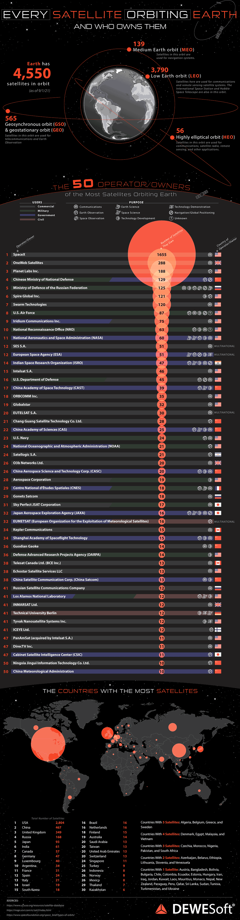
But only two other sat networks are OneWeb and PlanetLabs with one tenth the sats
https://www.datocms-assets.com/53444/1666338747-every-satell...
https://assets.publishing.service.gov.uk/media/67b5f85732b2a...
Page 86 is the start of the "Loss of Positioning, Navigation, and Timing (PNT) services".
I cannot tell you how infuriating it is as a UK tax payer on a UK-based ISP, that pays for this content to be made, to be blocked from viewing it.
Worse still, if I view the article in 'Private' browser mode then I can see it all.
More sanctions should have been imposed when they shot down a passenger plane and killed several hundred Dutch civilians.
The interesting question is how compromised British politics has been. Lots of very suspicious things (secret Boris Johnson meeting against the advice of security services; appointment of Lord Lebedev), but UK support for the Ukraine war has been unwavering.
I really hope this war ends, and ends up with Russia paying for repatriations, including this case.
(what is happening is turning the asset freeze into asset seizure, but this is complicated - rightly - by human rights law, because most of the assets are nominally private)
But outside of Ukraine, none of it crosses physical borders; the sabotage of undersea cabling is all done in international waters, the internet is some kind of free for all as well, etc.
What should have happened is that the international community stepped up and sent a clear message, like "Russia will be cut off from the internet if they do not stop their digital attacks". Boundaries mean nothing if there are no consequences to violating them.
Losing them however does drop capacity because now you need extra work to get planes to final.
Citation needed.
And VOR (VHF Omnidirectional Range) beacons are still used.
Many of the systems used are much older than people realize. Airports had ILS (instrument landing systems) in the 1950s. Improved low visibility versions started coming out in the 1970s.
A normal IFR approach has more relaxed minimums that you can get to with GPS so there are a lot of airports without any ILS system in place at this point. The GPS approach gets you down to minimums of something like 200 feet above ground at which you either have the runway in sight or abort the landing.
Likewise, VOR radios are slowly being retired and increasingly used as a fallback only. GPS systems in planes have been common for since end of last century. ILS and VOR infrastructure is kind of expensive to keep up and running and increasingly optional.
Navigation without GPS is not a problem for a commercial airliner. Landing without it in poor visibility is a different issue.
As of jamming most probably the new clock will not help. But for spoofing it probably can be prevented and mitigated with the new clock, but the root cause is the pseudo-orthogonality of the spread spectrum.
To put it simply, in housing property market the main criteria are three namely location, location, location. Similarly in communication and specifically in wireless the main criteria are also three namely orthogonality, orthogonality, orthogonality.
It's interesting to note that all mainstream GNSS systems including GPS, Galileo, GLONASS, and BeiDou are using spread spectrum modulation system, and they all affected by the pseudo-orthogonality of the spread spectrum system. There's a reason why the newer 4G/5G, and even Wi-Fi have moved away from spread spectrum modulation that's was being initially used by 3G and 802.11b, respectively, by fully embracing OFDM. The reverse-engineered Starlink modulation is reportedly using OFDM as well [1]. This mainly because of spread spectrum limitations but at the time it's not due to spoofing (security) but due to bandwidth scaling (performance) limitations. For GNSS on the other hand, don't care about the bandwidth because it's for location service not streaming video, but the limitations of being pseudo-orthogonal eventually got to them in the form of spoofing vulnerability.
The next generation GNSS designers perhaps need to bite the bullet, and should employ proper orthogonal modulation (OFDM or others), not pseudo one like spread spectrum. Having highly accurate on board clock is a hacked solution at best, not a proper solution, and it just unnecessarily increase the upfront cost and maintenance complexity by being overkill and over engineered.
[1] Reverse Engineered Signal Structure of the Starlink Ku-Band Downlink (2022) [PDF]:
https://radionavlab.ae.utexas.edu/wp-content/uploads/starlin...
The main purpose of the GPS spreading codes is to prevent self-interference from the other satellites and to increase the effective bandwidth for the cross ambiguity function (i.e., to get a nice, sharp cross-correlation peak in the time-domain). The pre-spreading data signal is only ~50 bits per second, so spectral efficiency is not a primary concern.
Please check my original comments as above.
Granted, it's still perhaps feasible to spoof OFDM system but it'll be much harder to pull off compared to the pseudo-orthogonal spread spectrum system [1],[2].
[1] Secure OFDM System Design and Capacity Analysis under Disguised Jamming (2019):
https://arxiv.org/abs/1804.07826
[2] OFDM-based JCAS under Attack: The Dual Threat of Spoofing and Jamming in WLAN Sensing (2025):
https://www.yahoo.com/news/south-korean-f-16s-just-162213039...
GPS jamming is unfortunate, but relying on U.S. GPS is foolish anyway (as the article also points out).
Planes still have inertial navigation systems. It worked before GPS, why not now? GPS for tracking phone users should go away anyway. If you are in an unknown city, but a damn paper map. No tracking and you absorb the big picture much faster.
Regular GPS is receive-only. GPS receivers naturally cannot be tracked. Tracking happens much higher up the stack, such as with your map app downloading local map tiles for display. Technology-wise, it's trivial to have a smartphone based map that is tracking-free, and the privacy focused alternate phone OSes do this already.